Our methodology works by gridding the available retrievals of column dust optical depth (CDOD) from TES and THEMIS nadir observations, as well as the estimates of this quantity from MCS limb observations. The resulting (irregularly) gridded maps were validated with independent observations of CDOD by PanCam cameras and Mini-TES spectrometers aboard the Mars Exploration Rovers "Spirit" and "Opportunity", by the Surface Stereo Imager aboard the Phoenix lander, by the Compact Reconnaissance Imaging Spectrometer for Mars and the Mars Color Imager camera aboard MRO, and by the MastCam camera aboard the Mars Science Laboratory "Curiosity".
Finally, regular maps of CDOD are produced by spatially interpolating the irregularly gridded maps using a kriging method. These latter maps are used as column-integrated dust scenarios in the Mars Climate Database (MCD) versions 5 and 6, and are useful in many modelling applications.
The two types of data set (irregularly gridded maps and regularly kriged maps) for the 13 available Martian years are publicly available and can be downloaded below (version 2.x).
The detailed description of the methodology and data sets can be found in the following scientific articles:
If you have no subscriptions to the journal Icarus or JGR, and cannot access the articles, please send an email to the address in the 'Contact' section below. Check the 'Contact' section also if you want to receive updates on future versions of the dust climatology.
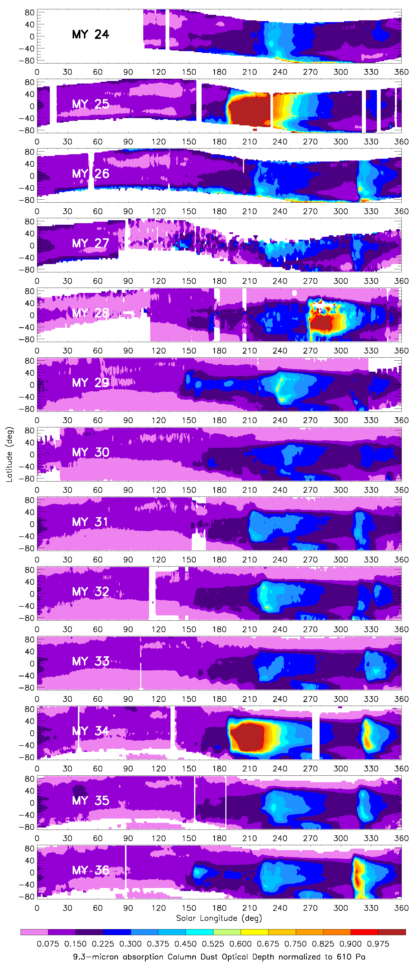
Daily irregularly gridded maps of 9.3 μm absorption column dust optical depth for several Martian years (MY). Spatial Resolution: 6° longitude x 3° latitude for MY24, 25, 26; 6° longitude x 5° latitude for the other Martian years. Temporal resolution: 24 hours (i.e. 1 map per sol). Data files are available in NetCDF format (74 MB for MY 24, 25, 26; 45 MB for MY 27 through 33; 50 MB for MY 34; 61 MB for MY 35, 36; 348 MB for the complete zipped tar file including all years). Plotted maps for the first 10 years (MY 24-33) are available as animated GIF (53 MB; each frame represents a sol-of-year with 10 maps, one for each available Martian year).
MY24 MY25 MY26 MY27 MY28 MY29 MY30 MY31 MY32 MY33 MY34 MY35 MY36 All MYs (tar.gz file)
Sub-daily irregularly gridded maps of 9.3 μm absorption column dust optical depth for MYs 34, 35 and 36. Spatial resolution: 6° longitude x 5° latitude. Temporal resolution: 6 hours (i.e. 4 maps per sol). Data file is available in NetCDF format (177 MB for MY 34, 221 MB for MY 35, 36).
Complete-coverage reconstructed maps (for Mars Climate Modelling):
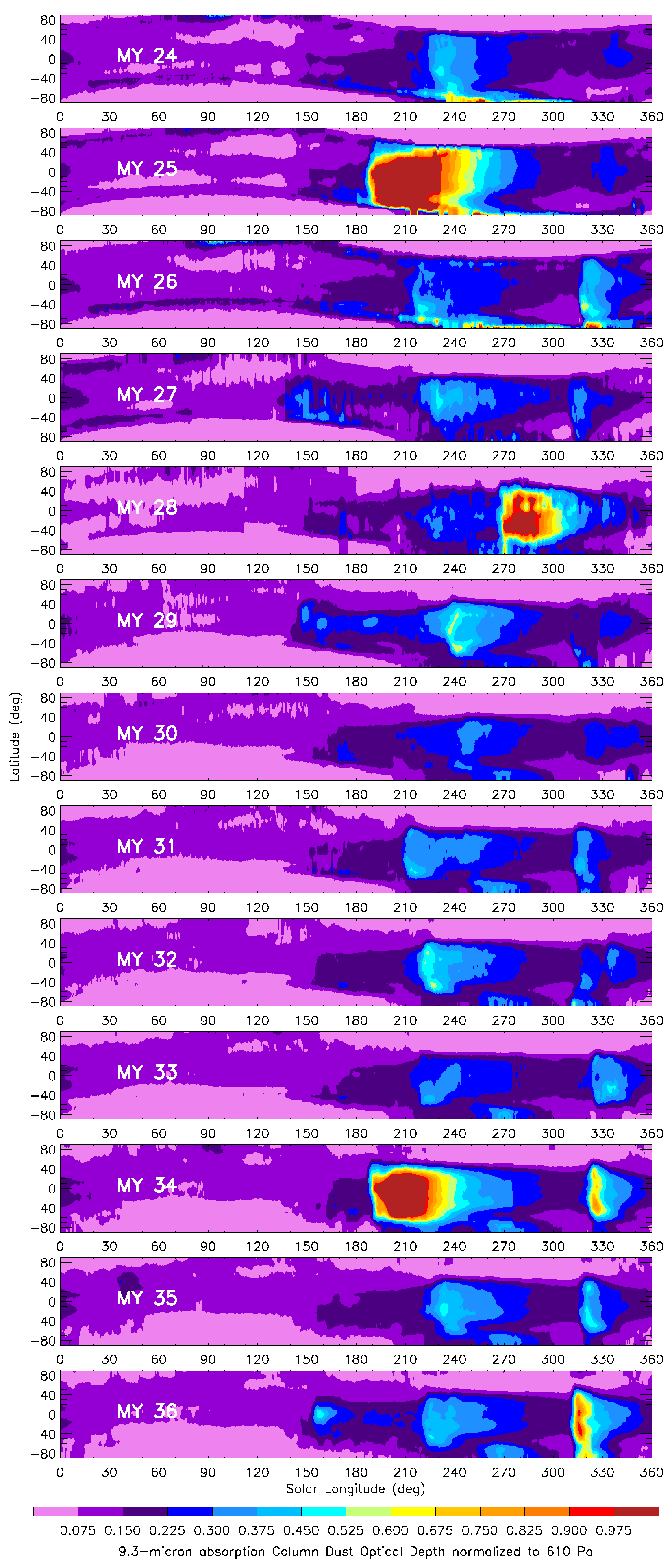
Daily column-integrated dust scenarios (regularly kriged maps of 9.3 μm absorption column dust optical depth) for several Martian years (MY). Spatial resolution: 3° longitude x 3° latitude. Temporal resolution: 24 hours (i.e. 1 map per sol). Data files are available in NetCDF format (56 MB for single year files; 591 MB for the complete zipped tar file including all years). Plotted maps for the the first 10 years (MY 24-33) are available as animated GIF (42 MB; each frame represents a sol-of-year with 10 maps, one for each available Martian year).
MY24 MY25 MY26 MY27 MY28 MY29 MY30 MY31 MY32 MY33 MY34 MY35 !New! : MY36 All MYs (tar.gz file)
Important notes:
Figures: (Left) Zonal means of the daily irregularly gridded maps of 9.3 μm absorption column dust optical depth normalized to the reference 610 Pa pressure level for the different Martian Years. (Right) Zonal means of the daily regularly kriged maps of 9.3 μm absorption column dust optical depth normalized to the reference 610 Pa pressure level for the different Martian Years.
Although we do not require any formal registration to download the data sets, we would highly appreciate if you tell us who you are if you download the files, and you will receive (sporadic) updates on future developments of the dust climatology. In order to do that, please fill and submit this very short Google Form including your name, affiliation (if applicable), email address, and planned use of the data sets. This would help us a lot to assess the impact of our work, and would make sure that we will keep you updated about possible errors, warnings, and future versions. We will not use your contact details for anything else than just keeping you updated about the data sets, when needed. You will always be able to unsuscribe by sending a request to the contact email above, should you no longer be interested in the MCD dust climatology.
These data are made publicly available on the condition that we provide no warranties regarding the reliability, validity or accuracy of the data, and we bear no responsibility for any use made of such data.